Peter (1.5.10) Blue's Greenfield
"Greenfield", The Search Begins
My search for Greenfield, started as we were planning the 2006 National Blue Family Reunion, which featured a trip to Danville, PA to research the Blues who settled there. Shortly before the reunion, Bill Blue forwarded me an e-mail that included the following tidbit.I have a copy of a patent for land on mohoning creek 1794 to peter blule dated dec 29 l794 in considration of monies paid by jean corry{Curry} for a tract of land called greenfield situate on small branches of the west branch of mahoing creek in mahoning township northlumberland county containing one hundred and fifty two acres and sixty perches wich said tract was surveyed in pursance of a warrant dated sept 29 1785 granted to said jean corry who by deed dated nov 13 1786 conveyed the same to the said peter blue
Peter Blue 1786 Deed
During the reunion, Selma and I made it to the Northumberland County Courthouse in Sunbury, where we found and photographed a deed dated 1786 and recorded in 1788, which included the following description of the property:Beginning at a Corner pine tree of Frederick Mause's land. Thence south eighty eight & a half degrees, West one hundred and fifty two perches to a dead pine stading in the line of George Caldwells land, Thence north one & a half degrees west, one hundred and seventy perches to a corner marked hickory, Thence north eighty eight and a half degrees east one hundred and fifty two perches to a Corner marked white Oak, Thence south one and an half degrees east one hundred and seventy perches to the place of Beginning containing one hundred & fifty two acres & sixty perches of land and the ususal allowance of six acres percent, be the same more or leſs.
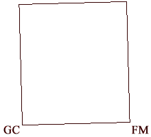
| S 88.5 W | 152 perches |
| N 1.5 W | 170 perches |
| N 88.5 E | 152 perches |
| S 1.5 E | 170 perches |
I extracted the bounds into a small data file (shown to the immediate right), and ran it through my plat program to produce the boundaries shown at the extreme right. Being a simple rectangle canted 1.5° counterclockwise, it was not terribly promising for my usual trick of terrain matching, especially given that the only boundary markers are trees and the property lines of Frederick Maus and George Caldwell, shown here by their initials.
The 1876 Atlas
I was resigned to a long search when the folk at the Montgomery House Museum and the Montour County Historical Society came to my rescue. The museum had a copy of an 1876 Atlas of Columbia & Montour Counties, which the MCHS has republished in 2002. We found the estate of Peter Blue, or more precisely "Est P.Blue", in the original, and purchased the reprint.
The following two maps show the location of Peter Blue's estate in the 1876 atlas (on the left), and in a topographic map fetched from TopoZone. (The scale of the topo map is the one I used to plot the boundaries above.)

1876 Atlas Showing Estate of P. Blue

Modern Topographic Map of the Area
Finding the House
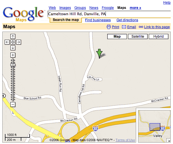 Using the atlas and Google Maps, we found our way to Cameltown Hill Road, a bit north of Interstate 80. We folled it to the bend in the road shown by the green arrow in the pipcture to the right, and found an old looking brick building screened by a row of trees to the east and across the street to the west a building with an old looking foundation. I took these to be the buildings marked "S.Blue" and "Est P.Blue" in the atlas.
We drove down the driveway to the Peter Blue Estate and found it owned by a delightful family who are "living plain", eschewing unnecessary modernisms in favor of more traditional values and lifestyle. They've made a number of improvements to the property in the last decade or two, but due to their lifestyle have done so in a way that is extremely consistant with the original. They tore down and old barn several miles away for timbers and boards to make an addition to the house, for instance. As a result, while the house is very livable in the 21st century, it conveys much of the feel of how it must have been two hundred and more years ago.
The lady of the house was feeling under the weather so we didn't impose and take a lot of pictures of the house, but I hope to return some day to do so.
Hendrickson Cemetery
After our visit, we continued north up Cameltown Hill rd to where the Atlas showed the "M.E. Ch. Cem." and found the Hendrickson Cemetery at Hendrickson United Methodist Church, which we later found had been surveyed by the Montour County Genealogical Society, and has a web page on their site. In it we found and photographed a number of gravestones of interest.
The graveyard has obviously been "tidied up" substantially since the early days. The foot stones have been moved, generally to stand next to the headstones, and so forth. This makes it a bit less clear as to who some of the markers are for. For instance, the MCGS list contains entries for "BLUE PETER 1868" and "P.B. MARKER". It appeared to us that these were Peter Blue's Headstone and footstone, now standing side by side.
The two most clearly interesting graves are a father and son pair, who are listed in Bill Blue's "Descendants Of John Blaw (Blue) d.1757 Somerset Co., NJ, Fifth Edition" as follows.
4Q
1.5.10.7 Peter BLUE (1796-1867), m. Julia Ann _____ (b.ca1808). They both were born in PA and they lived in Montour Co. PA.
1.5.10.7.1 David BLUE (b.ca1844). To Mercer Co. IL?
Their graves look like this:
| Peter (1.5.10.7) Blue | David (1.5.10.7.1) Blue |
|---|---|
 |
 |
| PETER BLUE Born June 13, 1796 Died Feb 22, 1868 Aged 71 years, 8 m. & 9 d. |
DAVID BLUE MAR. 19, 1844 JULY 30, 1912 REST IN PEACE |
These are the son and grandson of the Peter Blue whose estate, Greenfield, lies just south of the graveyard, if my analysis on this page is correct.
Peter Blue 1802 Deed
The next question that presents itself is "How does the 1786 deed relate to the 1802?" The description of that property reads as follows.
Begining at a pine a corner of Frederick Maus Land thence South two and one half degrees East fourty one perches to a post, thence South eighty seven and one half degrees West ninty seven perches to a Grubb, thence South two & one half degrees East twenty four perches to a post, thence North eighty five Degrees West eighty five perches to a pine, thence north one and one half degrees West Sixty perches to a Stump, thence North eighty eight and one half degrees East one hundred and Eighty three perches to the place of Beginning, Containing Fifty eight acres Sixty four perches Strict measure
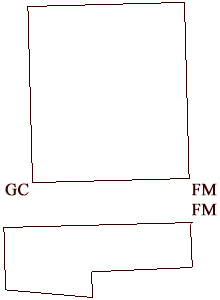
Noting that it starts "at a pine a corner of Frederick Maus land" and the 1786 starts "at a Corner pine tree of Frederick Mause's land", one can be forgiven, I think, for hoping that the two corner pines are the same and that the new plot is immediately to the south of the original Jane Curry plot. As it turns out, the two plats do seem fairly compatible, as seen to the right.
| S 2.5 E | 41 perches |
| S 87.5 W | 97 perches |
| S 2.5 E | 24 perches |
| N 85 W | 85 perches |
| N 1.5 W | 60 perches |
| N 88.5 E | 183 perches |