Anderson's Delight

Anderson's Delight, 1739
| Bounds from deed | |
|---|---|
| E | 100 poles |
| S 8 E | 124 poles |
| S 43 W | 60 poles |
| S 82 W | 236 poles |
Notes:
- According to Iona (Burrows) Jones (letter):
William Anderson came to Virginia in 1739, or at least by that date he owned several plantations in Virginia and Maryland. One was "Anderson's Delight" and another "Anderson's Bottom". Anderson's Delight was near Washington, DC.
- According to John Case Philips (e-mail):
Contrary to the foot note to John Anderson's letter about his father's family (I have the original) William was in Virginia long before 1739. His son Thomas was born at Anderson's Bottom in 1733. William sold Anderson's Delight in 1733, I have the surveyors platt- it was in Prince Georges County, Maryland. Prior to moving to Virginia William had used the Virginia property as his hunting and fishing vacation spot.
Note: The actual plat that John sent me is listed below and is actually dated 1739, not 1733.
- According to RootsWeb's Maryland Plats:
On Oct 24, 1739, Col. Thomas Cresap owned "Anderson's Delight" (212 acres) and Dr. George Stewart owned the adjacent "Elswick's Dwelling" (180 acres)

The RootsWeb site has a map of early settlers of Washington County, Maryland, which was created by Jerry B. Twigg based on the researches of Dr. Arthur G. Tracey. Unfortunately, the posted map is a rather severely damaged GIF. I have made a smaller cleaned up version of that map. The map gives the location of over 200 properties in the vicinity of Conococheague Manor including Anderson's Delight. The accompanying table contains the same names as the plat and the information is dated the same day, but the relationships shown are somewhat different.
The small picture to the right is a detail from Jerry's map, showing the locations of Anderson's Delight (89), Elswick's Dwelling (90) and Kelly's Purchase (91). The table to the right is an extract of the table that accompanies the Rootsweb map, listing these three tracts.
# |
Patent Date |
Acres |
Tract Name |
Owner |
|---|---|---|---|---|
| 89 | 10-24-1739 | 212 | Anderson's Delight | Col. Thomas Cresap |
| 90 | 10-24-1739 | 180 | Elswick's Dwelling | Dr. George Stewart |
| 91 | 10-24-1739 | 256 | Kelly's Purchase | Dr. Charles Stewart |
Note that the table lists Thomas Cresap as the owner of Anderson's Delight on Oct 24, 1739, but the plat shows it as Dr. George Stewart on the same date. (I previously had this as Oct 2nd, due to a transcription error.) Both place John Elswick to the northwest of Anderson's Delight.
Selma and I recently (mid-April 2001) did a bit of preliminary research on Anderson's Delight in Maryland, and based on what we learned at the Hagerstown library and Antietam National Battlefield, I believe I know where Anderson's Delight was located. We will be doing further Anderson research in a trip to Maryland and West Virginia in the spring of 2002, when I hope to be able to further confirm my current theories.
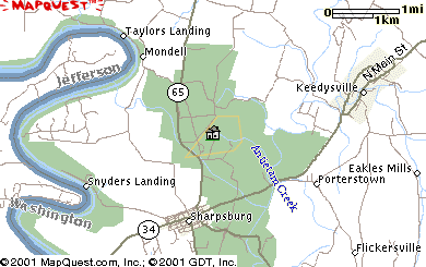 For now, my best guess is laid out in maps and pictures here. If anyone has any suggestions, please mail me. The map at the right shows the general location - just north of Sharpsburg, right in the middle of the Antietam battlefield. The park is shown in green. A map of the battlefield can be found
here.
For now, my best guess is laid out in maps and pictures here. If anyone has any suggestions, please mail me. The map at the right shows the general location - just north of Sharpsburg, right in the middle of the Antietam battlefield. The park is shown in green. A map of the battlefield can be found
here.
Next is a more detail topographic map showing the most probable location along with a large 89 to show the location given in the Jerry Twiggs map on Roots web. As you can see, I've located it a bit further south than Jerry's map, however, consulting a copy of Dr. Tracey's hand drawn map in the Western Maryland Room of the Hagerstown library, I find that he located it a bit further south than Jerry shows it.


The image to the right is a scan of a photocopy of the large full sized photocopy of Dr. Tracey's map in the Hagerstown library. It contains several details that would seem to support the location I've shown in the topographic map.
First, note the location of Dr. Tracey's grid lines. They intersect Anderson's Delight at the same points that the grids in the topographic map's grid. As Dr. Tracey doesn't label his grid lines, this proves nothing, but it is suggestive. More significantly, note the section of Anderson's Delight that is designated as "Joes Farm", and compare that with the pattern of fields shown below in the contemporary aerial photograph.
Finally, I used MSN's TerraServer to put together an aerial photograph of the area. I've scaled the MSN images to 2.5 meter/pixel, and used my plat drawing program to create an outline at the same scale from the 1739 George Stewart plat. The result is shown below. The blue outline shows the plat drawn exactly as given in the original. The red outline has been rotated 2° clockwise.

2015 addendum: I have created a Google Map version of the map together. It can be seen here:
or by visiting https://www.google.com/maps/d/edit?mid=zYaP-4Lnsn9E.kyPB1HwK55xY.